CentropeMAP je cezhraničný geoportál Rakúskej asociácie pre plánovanie východ (PGO), ktorý poskytuje plánovačom, rozhodovateľom, výskumníkom, učiteľom, študentom a všetkým ostatným záujemcom lepší prehľad o regióne Centrope.
CentropeSTATISTICS je výkonné rozšírenie geoportálu, ktoré umožňuje jeho používateľom vytvárať mapy, grafy a animované grafiky zo štatistických údajov na úrovni obcí pomocou niekoľkých kliknutí myšou.
*) Nefunguje správne? Nastavte svoj pop-up blokátor tak, aby nebránil stránke www.centropemap.org otvoriť nové okno vo vašom prehliadači.
Chart of the month December
On the occasion of World Soil Day, which is celebrated annually on 5 December, we are taking a look at the development of soil sealing in the Centrope countries. The chart shows an overall increase of sealed soil by 3.5 % from 2006 to 2018 in the EU-27 average. The development in Austria and Czechia is slightly better. Hungary's soil sealing increase follows the EU avarge, and Slovakia has a significantly higher level of soil sealing increase with almost 5 % from 2006 to 2018. Data source: https://ec.europa.eu/eurostat/databrowser/view/sdg_11_32//default/table
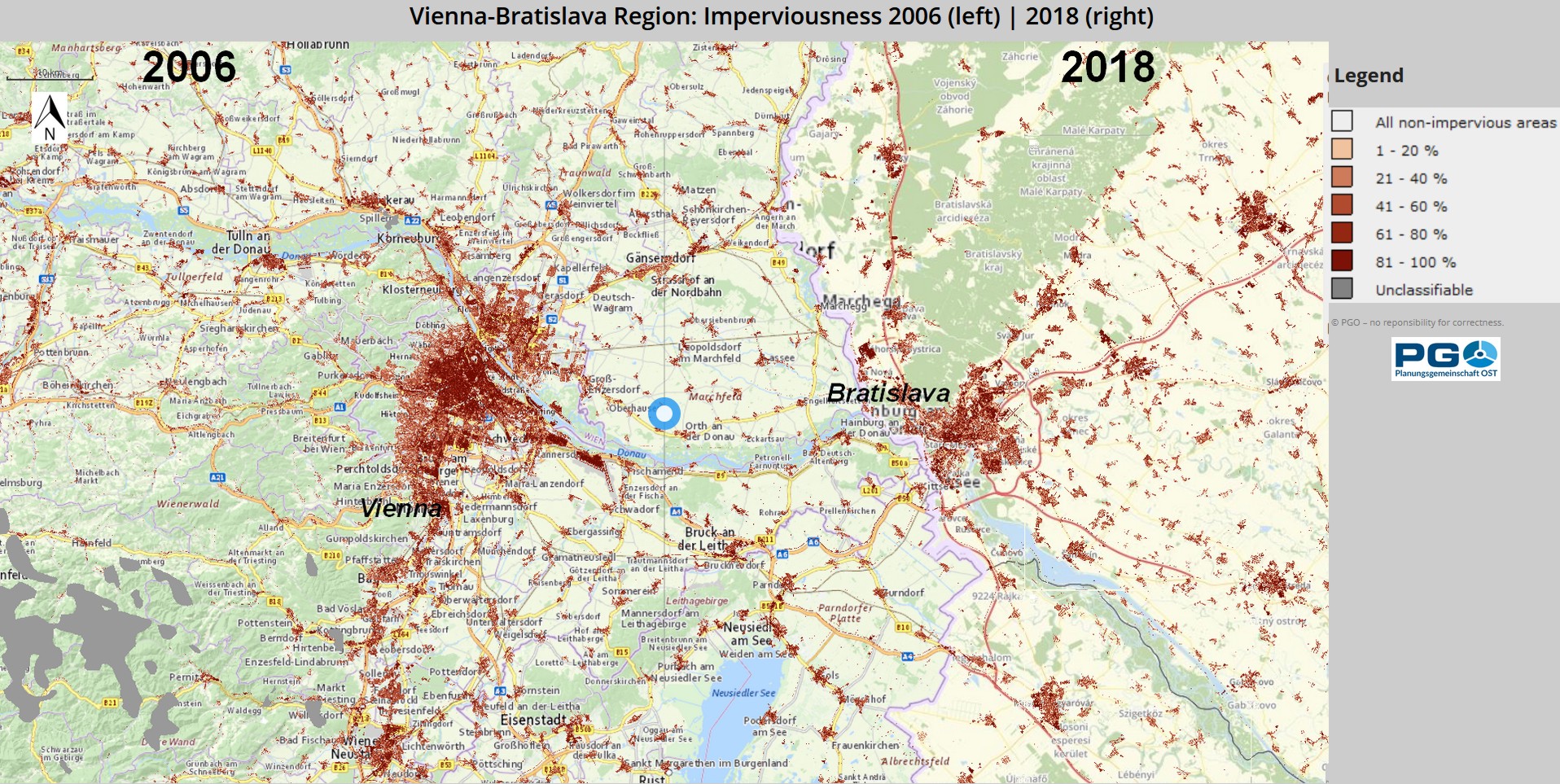
Map of the month December
World Soil Day is an international day of action on 5 December. It was designated by the International Union of Soil Sciences (IUSS) at its 17th World Congress in Bangkok in August 2002. On this occasion, we are taking a look at the development of imperviousness in the Centrope region, comparing data from 2006 and 2018. Slider maps are available for the surroundings of the larger cities in the region:
Open Map for Vienna-Bratislava region Open Map for Győr-Neusiedl/See region Open Map for České Budějovice-Jihlava-Brno region
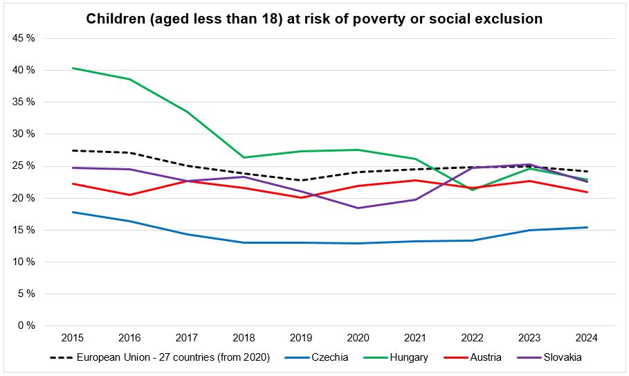
Chart of the month November
In keeping with the theme for November (World Children's Day), we want to take a look at the proportion of children (defined as those under the age of 18) who are at risk of poverty or social exclusion. The data for the Centrope countries show a similar trend in Austria, the Czech Republic, and Slovakia, which is also in line with the trend in the EU-27 as a whole. In Hungary, the proportion has been significantly higher in the past, levelling off around the EU average in 2018 and even falling below it at the beginning of the 2020s. Data source: https://ec.europa.eu/eurostat/databrowser/view/tepsr_lm412/default/table
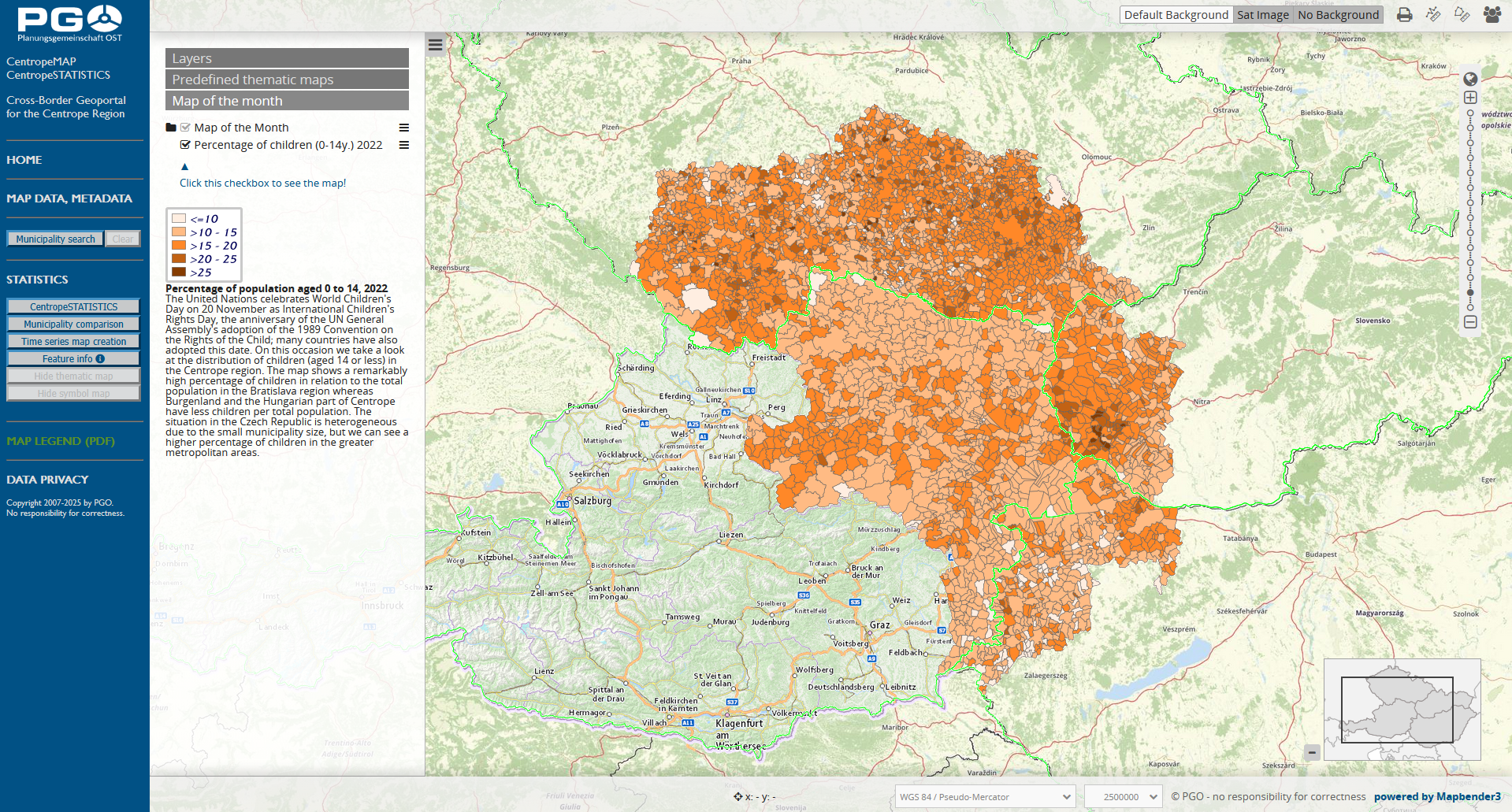
Map of the month November
The United Nations celebrates World Children's Day on 20 November as International Children's Rights Day, the anniversary of the UN General Assembly's adoption of the 1989 Convention on the Rights of the Child; many countries have also adopted this date. On this occasion we take a look at the distribution of children (aged 14 or less) in the Centrope region. The map shows a remarkably high percentage of children in relation to the total population in the Bratislava region whereas Burgenland and the Hungarian part of Centrope have less children per total population. The situation in the Czech Republic is heterogeneous due to the small municipality size, but we can see a higher percentage of children in the greater metropolitan areas.
Open our geoportal map.centropemap.org to view this map.
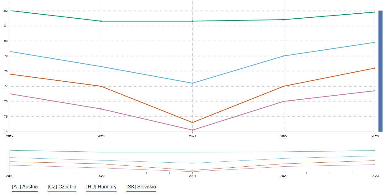
Chart of the month October
This time we are taking a look at the development of life expectancy in the Centrope countries. The timeline is similar for all of the four countries: Life expectancy is on the rise with a significant dip in 2020 and 2021 due to the pandemic. This dip was less pronounced in Austria, where also the general level of life expectancy is higher, followed by Czech Republic, Slovakia, and Hungary. Data source: https://ec.europa.eu/eurostat/databrowser/view/demo_r_mlifexp/default/table
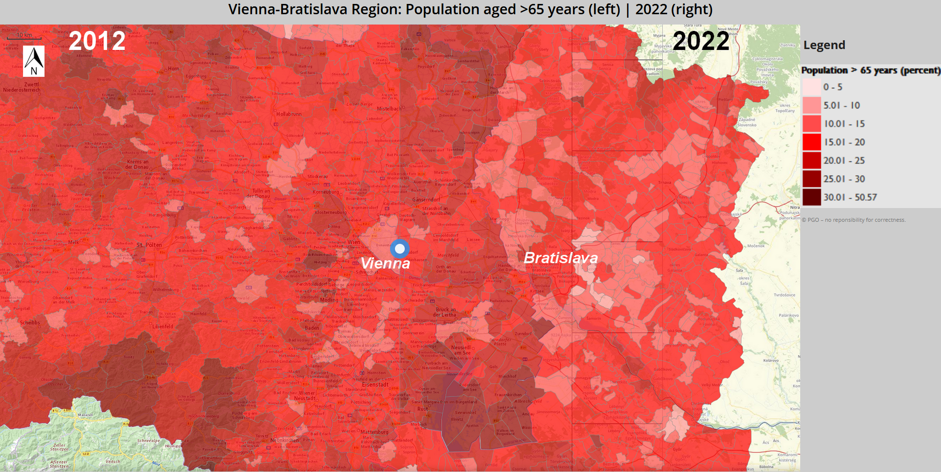
Map of the month October
International Day of Older Persons takes place annually on 1 October and was established by the United Nations General Assembly in 1990. It aims to draw attention to the challenges and needs of older persons, combat age discrimination and promote intergenerational solidarity. On this occasion we take a look at the development of older population (aged >65) over time in the Centrope region. The comparison shows data from 2012 and 2022. Slider maps are available for the surroundings of the larger cities in the region:
Open Map for Vienna-Bratislava region Open Map for Győr-Eisenstadt region Open Map for České Budějovice-Jihlava region


 Chart of the month December
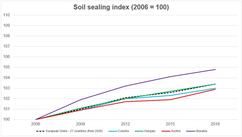 On the occasion of World Soil Day, which is celebrated annually on 5 December, we are taking a look at the development of soil sealing in the Centrope countries. The chart shows an overall increase of sealed soil by 3.5 % from 2006 to 2018 in the EU-27 average. The development in Austria and Czechia is slightly better. Hungary's soil sealing increase follows the EU avarge, and Slovakia has a significantly higher level of soil sealing increase with almost 5 % from 2006 to 2018. Data source: https://ec.europa.eu/eurostat/databrowser/view/sdg_11_32//default/table
 Map of the month December