CentropeMAP is a cross-border geoportal of the Austrian Planning Association East (PGO) which gives planners, decision makers, researchers, teachers, students and everyone else interested a better overview of the Centrope region.
CentropeSTATISTICS is a powerful extension of the geoportal allowing its users to create maps, charts and animated graphics from statistical data on municipality level with a few mouse clicks.
*) Does not work properly? Adjust your pop-up clocker so that it does not prevent www.centropemap.org from opening a new window in your browser.
Chart of the month October
This time we are taking a look at the development of life expectancy in the Centrope countries. The timeline is similar for all of the four countries: Life expectancy is on the rise with a significant dip in 2020 and 2021 due to the pandemic. This dip was less pronounced in Austria, where also the general level of life expectancy is higher, followed by Czech Republic, Slovakia, and Hungary. Data source: https://ec.europa.eu/eurostat/databrowser/view/demo_r_mlifexp/default/table
Map of the month October
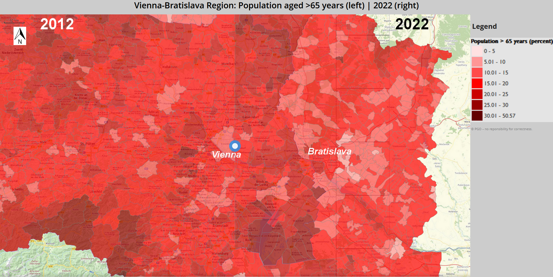
International Day of Older Persons takes place annually on 1 October and was established by the United Nations General Assembly in 1990. It aims to draw attention to the challenges and needs of older persons, combat age discrimination and promote intergenerational solidarity. On this occasion we take a look at the development of older population (aged >65) over time in the Centrope region. The comparison shows data from 2012 and 2022. Slider maps are available for the surroundings of the larger cities in the region:
Open Map for Vienna-Bratislava region Open Map for Győr-Eisenstadt region Open Map for České Budějovice-Jihlava region
Chart of the month September
20 September marks World Children's Day, established by the United Nations. To mark the occasion, we take a look at a related topic, namely the age at which young people leave their parents' home. The figures are consistent across the observation period, but it is striking that young people in Slovakia in particular leave home relatively late. Hungary's figures are also slightly above the EU average, while Austria is just below and the Czech Republic is in line with the average. Data source: https://ec.europa.eu/eurostat/databrowser/view/yth_demo_030/default/table
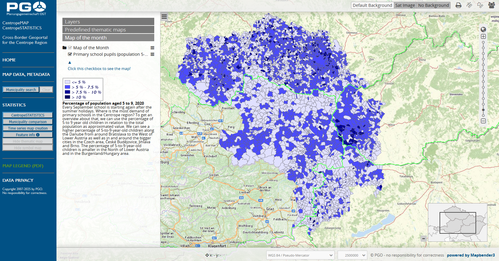
Map of the month September
Every September school is starting again after the summer holidays. Where is the most demand of primary schools in the Centrope region? To get an overview about that, we can use the percentage of 5 to 9 year old children in relation to the total population as approximated value. We can see a higher percentage of 5-to-9-year-old children along the Danube from around Bratislava to the West of Lower Austria as well as in and around the bigger cities in the Czech area, České Budějovice, Jihlava and Brno. The percentage of 5-to-9-year-old children is amaller in the North of Lower Austria and in the Burgenland/Hungary area.
Open our our geoportal map.centropemap.org to view this map.
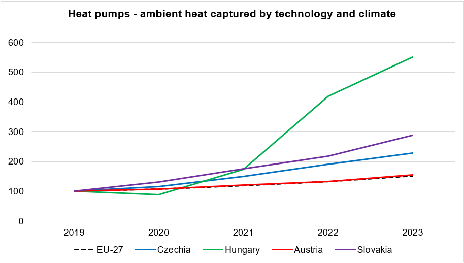
Chart of the month August
This time we are going to take a look at the development of heat pump technology in the Centrope region. The dataset covers the indicator for monitoring progress towards renewable energy targets of the Europe 2020 strategy implemented by Directive 2009/28/EC on the promotion of the use of energy from renewable sources (RED I) and the Fit for 55 strategy uner the Green Deal implemented by Directive (EU) 2018/2001 on the promotion of the use of energy from renewable sources (RED II). For better comparison, the absolute values in Gigawatt hours were indexed with 2019 = 100. It is remarkable that the Austrian numbers are almost exactly following the EU-27 average whereas the incline in the other countries is much higher. However, if you compare the indexed values with the absolute numbers, you will find out that the reason for this development is that the the Czech Republic, Slovakia, and especially Hungary need to catch up with the European level and therefore are having a higher improvement rate.
Data source: https://ec.europa.eu/eurostat/databrowser/view/nrg_ind_ahbtc/default/table
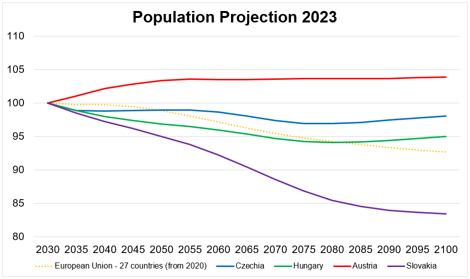
EUROPOP2023 are the latest Eurostat long-term population projections produced at national level for 30 countries: all 27 European Union (EU) Member States and three European Free Trade Association (EFTA) countries (Iceland, Norway and Switerland), covering the time horizon from 2022 to 2100. Population projections are 'what-if scenario' that aim to show the hypothetically developments of the population size and its structure based on a sets of assumptions for fertility, mortality and net migration; they are presented for a long time period that covers more than a half-century (50 years). The chart shows a slight population increase in Austria in the first half of the century, whereas the population in the Czech Republic stays on a constant level. Hungary's population will be decreasing with a turnaround towards the end of the century, and Slovakia has to face a massive loss of population throughout the whole time period covered. Data source: https://ec.europa.eu/eurostat/databrowser/view/proj_23np/default/table


 Chart of the month October
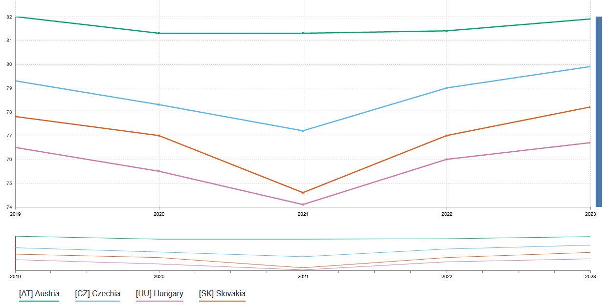 This time we are taking a look at the development of life expectancy in the Centrope countries. The timeline is similar for all of the four countries: Life expectancy is on the rise with a significant dip in 2020 and 2021 due to the pandemic. This dip was less pronounced in Austria, where also the general level of life expectancy is higher, followed by Czech Republic, Slovakia, and Hungary. Data source: https://ec.europa.eu/eurostat/databrowser/view/demo_r_mlifexp/default/table
 Map of the month October